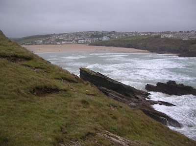
Porth Island from across the bay
Short footbridge connecting Porth Island with the mainland
Blowhole looking north east towards Whipsiderry
More oystercatchers than I have ever seen in one place. I think they were waiting for the weather to improve! Looking south west towards Newquay
Looking down into the blowhole.
When there was a particularly big wave the spray reached up well above ground level
Long narrow Geo at the western end of the island
When there was a particularly big wave the spray reached up well above ground level
Long narrow Geo at the western end of the island
The highest point on the island
A very narrow rocky and slippery path leads around the western end of the island.
Looking south east towards Porth
This rock is apparently known as Norwegian Rock
It is located directly to the north of the footbridge
It is located directly to the north of the footbridge
I visited in 2006 to look for a geocache but had forgotten that it is an island. It isn’t very large but has several interesting natural features including cliffs, a blowhole and a geo.
It was populated in the Bronze and Iron Ages. There are 2 Early Bronze Age barrows on Trevelgue Head, which is at the western end of the island and is the highest point on the island. These consist of cists (stone lined boxes) containing cremated human remains, which were then covered with an earth mound. There was an excavation of the barrows in 1840 by Canon Rogers and in 1872 led by William Copeland Borlase Neolithic flint tools have also been discovered on the island.
There was a major excavation on the island in the summer of 1939 led by C.K. Croft Andrew but the work was halted by the start of the Second World War. A survey was carried out by the Cornwall Archaeological Unit in 1983. There was a farm on the island in the Iron Age with a large roundhouse of 4.5 metres in diameter, which was probably a meeting place, with several smaller roundhouses located around it. There was a terraced field system. Evidence from the remains of the middens indicates that sheep, cattle and goats were kept and deer were also eaten. More than 4,000 sherds of decorated pottery were found along with glass rings and beads, querns for grinding corn and spindle whorls for spinning wool. The remains of iron, tin and copper smelting activities were also found – furnaces, ore roasting pits and slag.
There are the eroded remains of 8 large earth and stone ramparts and rock cut ditches (5 on the mainland and 3 on the island), which formed an Iron Age cliff castle.
Later Roman pottery and coins have also been discovered on the island.
Today the island is uninhabited and not grazed, except by rabbits. It is grass covered with wildflowers such as thrift. There are a couple of interpretation boards, which were erected in 2007 with historical and archaeological information and an artist’s impression of what the island would have looked like in the Iron Age. It is popular with dog walkers and there were some people fishing off the rocks when I visited.


